Towards A Data Standard For Curb Regulations
By Emily Eros in Pilot Perspective · June 5, 2019
Introducing CurbLR
As street users compete over limited space to park cars, hail a ride, deliver packages, and drop off scooters, curb management is a key issue in cities. To better manage demand, cities first need an inventory of supply: structured data about where curbspace exists and how it’s currently regulated. Government agencies, private companies, and mapping enthusiasts have been seeking a standardized approach to handle this regulatory information, with much talk of creating a “GTFS for the curb”.
SharedStreets is developing CurbLR, an open standard for curb regulation data, in collaboration with Ford Mobility. We’re sharing this first draft as an invitation for collaboration with cities and private sector innovators interested in curb data. If you have thoughts or feedback, we’d love to hear from you.
CurbLR provides a structured way for all cities to store and share essential curb information, incorporating asset information that’s been linear referenced onto the street using the SharedStreets Referencing System. It’s a common language on which many things can be built, including rules engines, query APIs, consumer notification services, mapping tools, and analytic models.
To develop this standard, SharedStreets approached curb regulations from a variety of angles to understand the challenges across the life cycle of the data, from creation to consumption. We worked with cities like DC, Seattle, and LA to understand how they collect and store data about the curb. We reviewed cities’ open parking regulation datasets and collaborated to develop linear-referenced datasets. We field mapped parking restrictions in our own neighborhoods, experimented with using different proposed standards, and worked closely with companies seeking to create and ingest curb regulation data.
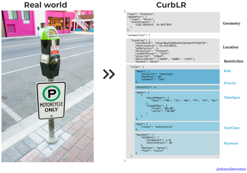
Here’s an example of what a physical asset, like a parking meter, looks like once it’s been converted to CurbLR:
How Does it Work?
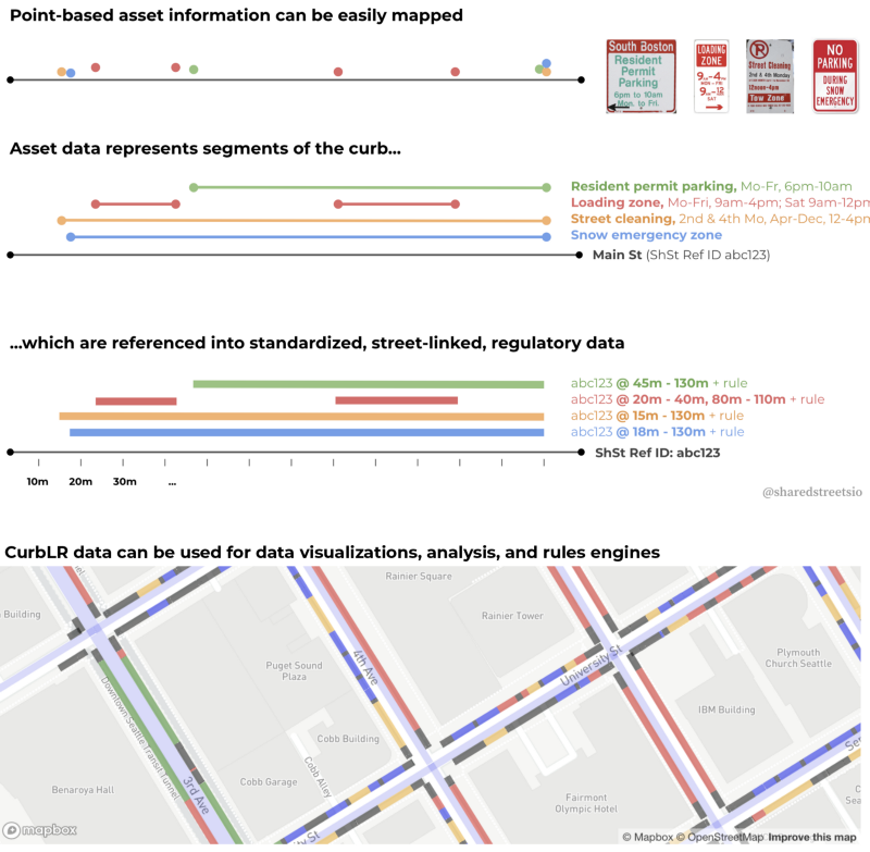
Government agencies and companies typically store parking restrictions as point-based asset data. The assets themselves are easy to map, but the concepts they represent are not. Curb regulations don’t have a perfect, 1:1 relationship with physical space. They represent regulatory geometries, not physical geometries.
To handle this, CurbLR uses asset data as the building blocks for a spec, but supplements that with additional location information and structure. First, CurbLR includes linear references that relate assets to their location along a street, using the SharedStreets Referencing System. In addition, It provides a template to store structured data about the curb rule itself, including what is being restricted or allowed, when a rule applies and for whom, how it is applied, and how it relates to overlapping regulations.
Here’s a visual overview:
Thoughts? Questions? Feedback?
CurbLR is an evolving proposal for a data standard, and we’re actively seeking feedback on what works and what could be improved. You can find the full documentation on GitHub, including a number of examples and a translation of Los Angeles’ parking regulations into CurbLR.
If you have thoughts or feedback, we’d love to hear from you. Don’t hesitate to reach out and let us know what you think!
This is a living document. GitHub is the most up-to-date source for information.


Get Involved
Do you work for a city or government agency? A private company? Or are you an independent researcher or developer? Learn how to start using the SharedStreets Toolkit.
Get Started