Introducing SharedStreets Road Closures
By Indraneel Purohit in Pilot Perspective · June 3, 2019
Cities open and close parts of their road network on a daily basis to keep their cities moving. Today, it is difficult to easily produce and consume closure data across city governments, consumer facing mapping apps and service providers.
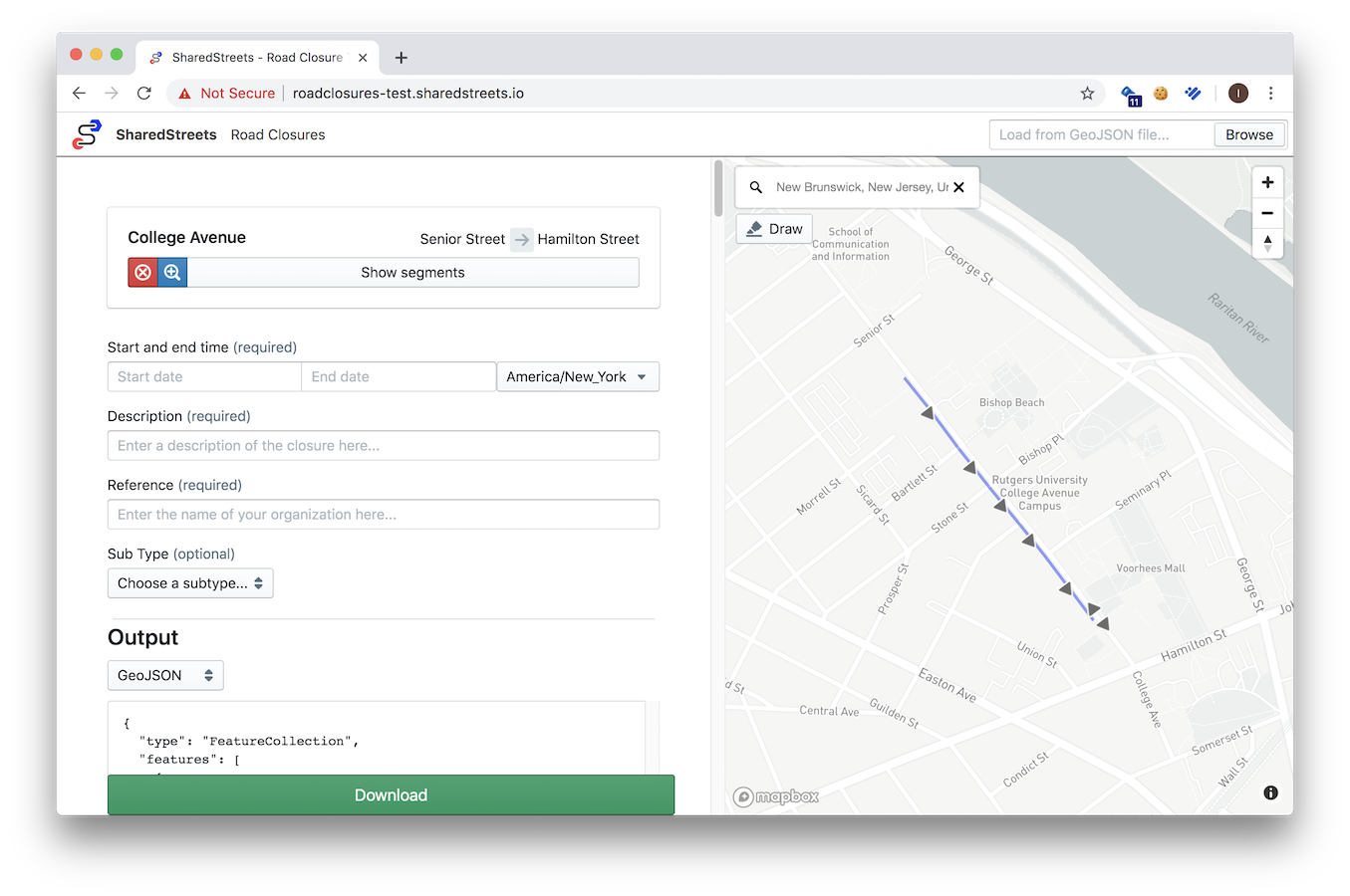
A shared, machine-readable language for describing where closures occur on the road network, makes closure information easier for governments to produce and anyone to consume, which is why we built SharedStreets Road Closures — an open source web app built for cities to produce data on road closures easily and consistently.
We’ve made it simple to get started: open the web app, select the streets you’re closing, and download the closures as either a GeoJSON or CIFS JSON file. Since the app creates data linked to the street using the SharedStreets referencing system, it is easily translated to any map.
This post will go through each step in detail. To get started with the app right now, click here.
1. Add Road Closure Data
We created SharedStreets Road Closures for all cities, especially for those without an existing digital map-based process of marking roads as closed.
Cities can use the web app today to select the roads they are closing and it will display the streets matched to the SharedStreets referencing system. Since the app is powered by the SharedStreets referencing system — no GIS setup or experience required and all data has a shared reference that can be used across maps.
Cities with an existing map-based process can use the SharedStreets CLI to link their road closure data to the street.

2. Share Road Closure data
Once closure data is produced, cities can download the data from the app and attach it in communications within their city government or out to individuals and companies that consume closure data. Also, GeoJSON files downloaded from the app can be re-uploaded back into the editor as a way to manage and make changes to closures.

Consumers of closure data can rely on the consistency of the information to automate management of new data, and they can leverage the included SharedStreets reference IDs in tandem with the SharedStreets referencing system to translate closure information into their own basemaps(see our example with speeds data for more about this).
Closure data sets are often small in size and can be published on any public-facing web file server, but distributing data comes with its own set of challenges. Cities either need to set up their own hosting infrastructure, or purchase cloud storage. From a technical standpoint both options are relatively simple, but from our discussions with city users we’ve learned that IT procurement rules may add complexity.
To help cities distribute data we are testing a way to publish and create a link to their closure data hosted publicly by SharedStreets. This is a technically straightforward solution, but opens related issues around data discoverability, long-term storage, and verification of the identity, and authority of publishers. Many of which are not unique to closure data. We’re actively exploring these questions, and examining similar challenges presented by existing city-published data sets like GTFS. We welcome feedback and collaboration, and will be sharing more on data distribution solutions in future updates.
Getting started
Cities can start creating data in SharedStreets Road Closures web app today. All the source code for the app is available on GitHub. We also use GitHub for feedback, so please submit an issue there or contact us directly if you have any thoughts, questions, comments or concerns!


Get Involved
Do you work for a city or government agency? A private company? Or are you an independent researcher or developer? Learn how to start using the SharedStreets Toolkit.
Get Started