Using Location Data for Guiding Micromobility Outcomes
By Morgan Herlocker in Data Deep Dive · March 26, 2019
Scooter and bike share services present cities an opportunity to move more people in less space while providing more equitable transportation options. Most cities expect private mobility companies to further policy goals around safety, equity, and sustainability in return for their use of public infrastructure. Location data — information about where things are in the world, such as phones or scooters — is ubiquitous today, and can help monitor how micromobility services interact with street infrastructure. This post will explore the capabilities of this data, as well as the hardware limitations.
Location Accuracy
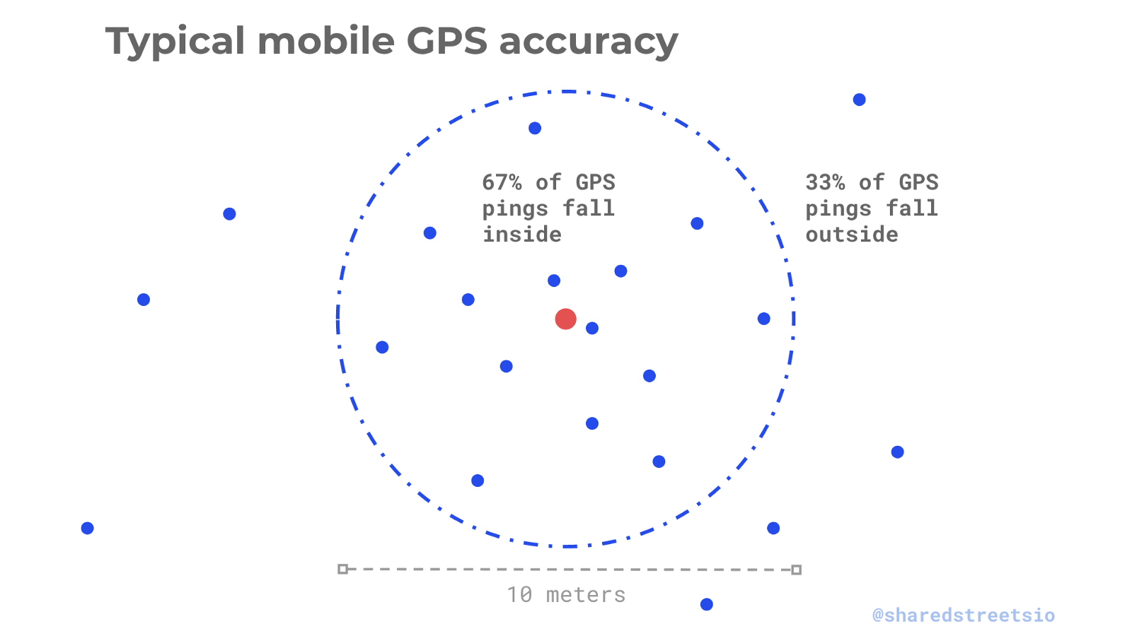
Most location data today is derived from multiple sources on a device — GPS, Wi-Fi triangulation, and cell tower triangulation. While none of these sources are pinpoint accurate, each has well understood models for estimating accuracy and noise. The ensemble models used by modern consumer hardware combine these errors to create a statistical estimate of how closely reported locations map to ground truth called “horizontal accuracy”. Horizontal accuracy is reported as a distance radius plus a confidence interval that any reported location is within that radius from ground truth. For example, a phone with a good signal will commonly report a lower bound of 10 meters horizontal accuracy with a 67% confidence interval. This means that for a device continuously reporting its location while sitting still, about 2/3 of the reports will be less than 10 meters away, while the remaining 1/3 of reports will be farther away.
Micromobility Enforcement
Many of the proposals for using location data to enforce appropriate use of micromobility — parking properly, riding safely — rely on the concept of geofencing. Geofencing is the process of determining when a device has crossed inside of a predetermined geographic boundary. For scooters, many agencies are interested in enforcing parking and speed zones using location data. This is possible, given an appropriately large geofence and tolerance for false positives, however the minimum boundary size is considerably larger than the width of a parking space or sidewalk.
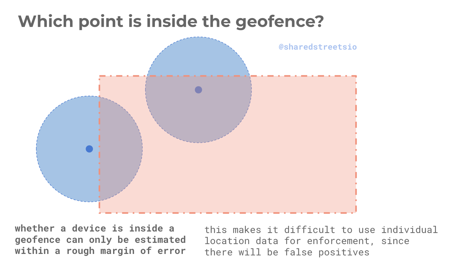
Instead of probabilistically determining whether a particular scooter violated a rule, cities should use location data in aggregate to understand how people interact with infrastructure, and use signage and other forms of enforcement to guide behavior. If geofencing is a hard requirement, applying noise filters to location data and calculating acceptable false positive statistical thresholds is needed.
Update Frequency
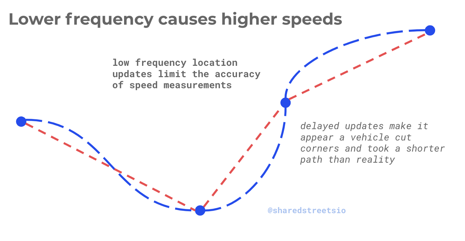
Another issue to expect when ingesting location data is fluctuations in reporting frequency. Frequency is the measure of how often a location update is collected per device. Location data frequency can vary widely depending on a wide range of factors such as operating system, battery level on device, and physical obstructions that block a GPS receiver’s connection to satellites and cell towers. When location updates are made at lower frequency, it creates the appearance of a device taking “shortcuts” through city blocks.
The impact of this effect is that location data can only be used to estimate the speed of a vehicle to around 7 miles per hour of precision. Considering scooters only travel at a max speed of 20 miles per hour, this error range makes it nearly impossible to reliably enforce speed restrictions using location data alone. Instead, cities should measure aggregate speeds through safety corridors, which can be measured with a much higher level of accuracy. If prevailing speeds are higher than safety allows, cities can work with companies on hardware modifications for speed caps, post additional signage, or station a physical presence in the area of concern.
High Level Patterns
Most of the policy outcomes a city is interested in enabling for micromobility center around city wide or neighborhood level behaviors, rather than the activity of a single individual vehicle. For example, ensuring that a scooter service has sufficiently allocated vehicles to underserved neighborhoods or making sure that provider does not flood the streets with more vehicles than they have licensed. For these types of policies, location data presents a highly reliable signal and an opportunity to drive better usage of our cities’ transit infrastructure.


Get Involved
Do you work for a city or government agency? A private company? Or are you an independent researcher or developer? Learn how to start using the SharedStreets Toolkit.
Get Started